In regions like the Sahel and the Horn of Africa, where insecurity and inaccessibility often prevent journalists, investigators and humanitarian actors from reaching the ground, satellites have emerged as powerful tools shaping the enforcement of international humanitarian law (IHL) and the practice of open-source intelligence (OSINT) journalism.
How Satellites Track Conflict and Displacement
Satellite imagery has fundamentally transformed how conflicts are observed. Governments now rely on it for border surveillance and security monitoring, while humanitarian organizations such as the World Food Programme and the International Committee of the Red Cross use it to assess damage and displacement in areas that are otherwise inaccessible.
Since the start of Sudan’s conflict in April 2023, over 3,000 requests have been registered with humanitarian agencies by people searching for missing loved ones. Journalists and OSINT investigators have been using satellite data to verify attacks, trace military movements, and counter disinformation in the ongoing civil war, where clashes between the Rapid Support Forces (RSF) and the Sudanese army have left vast areas of the country beyond the reach of independent observers.
According to the UN Office for the Coordination of Humanitarian Affairs (OCHA), the Sahel and the Horn of Africa are among the world’s most conflict-affected regions. From Sudan’s ongoing civil war and Ethiopia’s internal conflicts to insurgencies in Mali, Burkina Faso, Niger, and Somalia, where Al-Shabaab continues to commit atrocities, the conflict often unfolds far from journalists, investigators and humanitarian workers.
According to the Armed Conflict Location & Event Data Project (ACLED), civilian targeting in the Sahel has increased over the past 5 years, with Burkina Faso and Mali ranking among the deadliest conflict zones globally.
In Sudan alone, the International Organization for Migration estimates that over 8 million people have been displaced since fighting began in April 2023.
Many of these areas remain inaccessible due to ongoing insecurity or deliberate restrictions imposed by warring parties.
Satellite imagery helps overcome these barriers, allowing governments, humanitarian organizations and journalists to track military movements, monitor attacks on civilians, and observe displacement patterns, even in areas controlled by the Rapid Support Forces (RSF) and the Sudanese army.
OSINT Journalism: Seeing What Cannot Be Reached
Open-source intelligence journalism combines satellite imagery, geolocation, social media verification and eyewitness accounts to reconstruct events remotely.
By confirming military activity, including troop movements, fortified positions, and airstrikes, OSINT provides the tools to verify stories where traditional reporting cannot reach.
In the Sahel and Horn of Africa, OSINT fills important gaps in coverage, enabling journalists to document patterns of violence and displacement that would otherwise remain invisible.
Research institutions and newsrooms increasingly rely on satellite imagery to verify attacks on civilian infrastructure, document mass atrocities and track displacement.
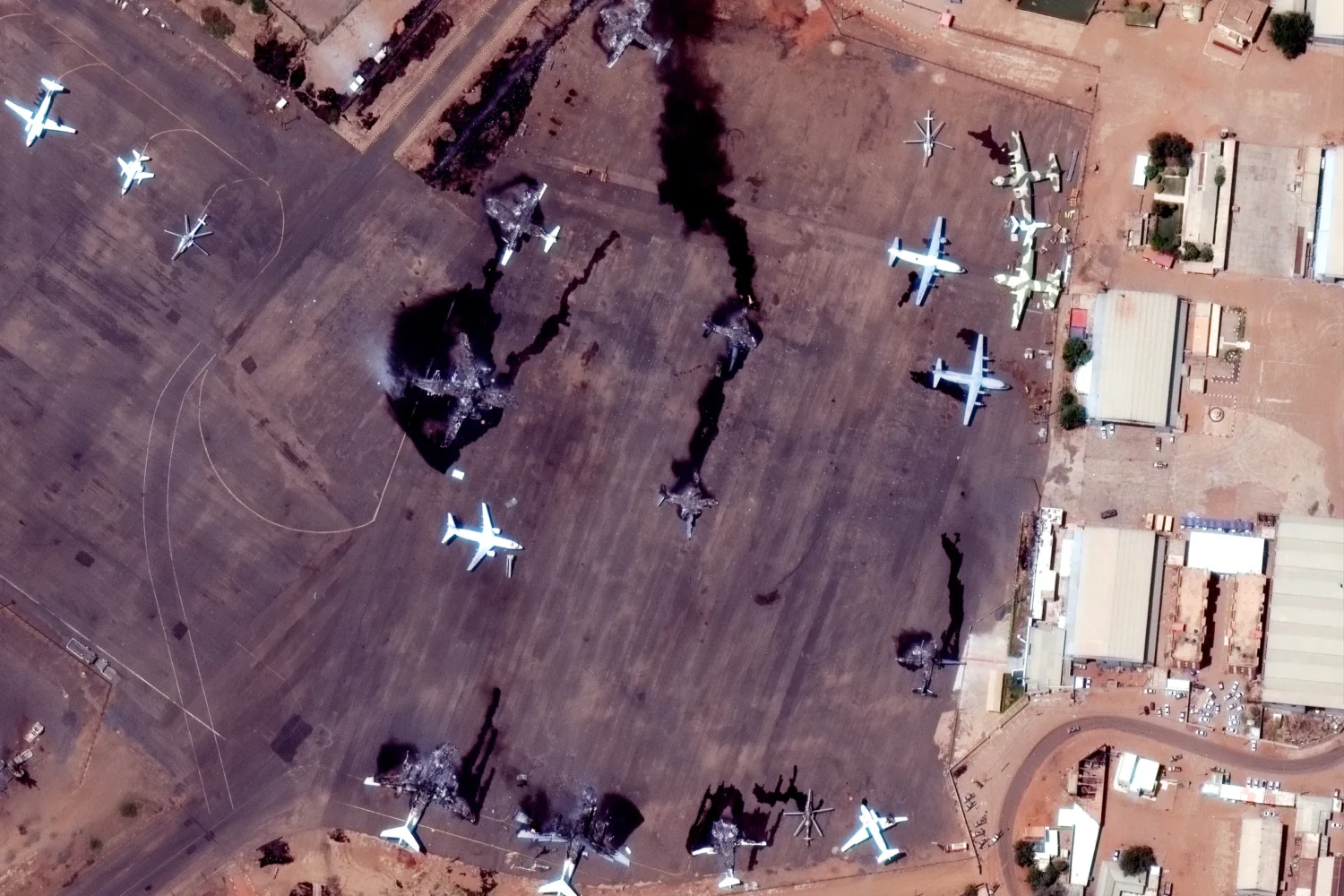
In Sudan, the paramilitary Rapid Support Forces (RSF) have carried out a campaign to erase evidence of mass killings in El Fasher.
Satellite analysis conducted by the Yale Humanitarian Research Lab identified burned settlements, mass graves, and scorched farmland, revealing the deliberate targeting of civilians attempting to flee the city or seeking refuge in neighborhoods such as Daraja Oula.
Satellite imagery has also helped track the expansion of informal displacement camps and abandoned farmland, corroborating reports of humanitarian crises in locations such as the Zamzam camp for internally displaced persons.
Space Evidence and War Crimes Documentation
The war in Sudan offers one of the best examples of how satellite imagery supports IHL enforcement and OSINT reporting.
With cities like El Fasher in North Darfur sealed off to journalists and UN investigators, satellite imagery has revealed evidence consistent with mass killings, alleged ethnic cleansing and the destruction of civilian areas.
Analysis by Yale HRL identified:
- clusters of objects consistent with human remains
- newly disturbed earth indicating mass graves or incineration pits
- widespread burn scars across residential areas
- abandoned markets and empty urban centres once home to over 1.5 million people
While estimates of the death toll vary, British parliamentarians were briefed that tens of thousands may have been killed in El Fasher alone within weeks. Satellite imagery makes it much more difficult for those committing atrocities to hide their actions, even when bodies are buried or burned.
Space, IHL, and the Rules of War
Satellite imagery increasingly underpins the application of international humanitarian law. While the 1967 UN Outer Space Treaty establishes the peaceful use of outer space, it places limited restrictions on military activity. IHL, however, governs all forms of warfare, including those enabled by space-based technologies.
Core IHL principles; distinction, proportionality, and military necessity, require that armed forces distinguish between civilian and military targets and avoid excessive civilian harm. Satellite imagery helps investigators assess whether these principles have been violated by documenting patterns of destruction, civilian casualties and the use of force.
In several Sahelian conflicts, satellite data has been used as corroborative evidence in allegations of war crimes, particularly where governments or armed groups deny responsibility.
From Observation to Justice
Space has reshaped how wars in the Sahel and the Horn of Africa are documented. However, technology alone is not enough.
Without inclusive frameworks that prioritize local voices, ethical data use, and equitable access, satellite imagery risks becoming another tool of distant power.
As wars across Africa continue to be watched from orbit, the real test is whether space technology will merely observe suffering or help deliver justice for those living beneath the satellites’ view.